Before my first visit to Grenell in 1975, my then fiancé - now husband, Gary, showed me the lot map of Grenell drawn in the early 1880s. I already knew there were no cars on the island, so I was surprised to see streets on the map. “There are streets?” I asked.
“No roads,” he told me. “Mostly sidewalks, but on the north side of the island there is just a footpath.” I studied the map and memorized the names. Two sounded like streets on a Monopoly Board: St. James Place and Park Avenue. Of course the reality of what I encountered on the island was nothing like I’d imagined.
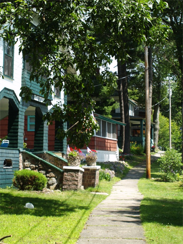
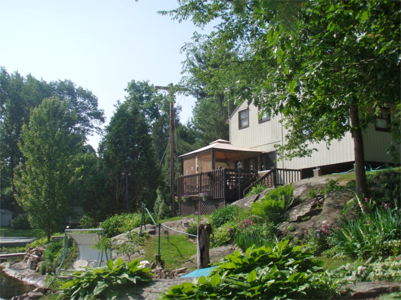
Immediately, I considered the south side of the island the more civilized side, with cottages lined up along a sidewalk just like a little town. The north side of the island was another story. Here, there isn’t a sidewalk , just a narrow path that goes up over rocks and tree roots. I call it the Billy Goat Side of the island.
Last summer while collecting Grenell Island history I spoke with a resident who suggested a new map be drawn with cottages on it and the paths more accurately represented. She got out a map she had drawn when her daughter got married a few years ago. The wedding party had rented several cottages on the island and she had drawn a map for the guests to help find their way around.
The 1880-era Lot Map shows the path running along the shoreline on the north side. The 2000-era wedding map had been redrawn to correctly show the path weaving sometimes in front of and sometimes behind the cottages on the north side. She was interested in improving on her efforts and said she couldn’t find any trace of Crescent Ave. or St. Lawrence Avenue and wondered if the Grenell Island Improvement Association (GIIA) ever planned on re-establishing the public paths in these areas.
I explained that the “public path” is a myth. The path we walk on is really the private property of the cottage owners. This revelation was followed by stunned silence. The look on her face pained me. It was like I’d just told a five-year-old there was no Santa Claus. Her silence was quickly filled in with questions: When did that happen? Just recently? But what about the sidewalk? Isn’t that public property?
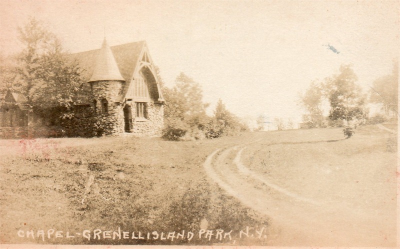
The sidewalks had been public easement. In fact, one of the reasons, the GIIA had been formed was improvement of the public paths. The first thing the new association did in 1912 was to install a sidewalk along St. James Ave and then a sidewalk from St. James to the Chapel. Sidewalks were extended as funds permitted. Eventually, St. James and St. Marks were completely paved as well as parts of South Boulevard, Park Avenue and Highland Avenue.
The north side was never paved over, but the GIIA did what it could to maintain the path. Kids, like Charlie and Stu Clough, were often employed in this task. These were the days before gas powered lawn mowers or weed wackers. Armed with a grass whip (scythe), the Clough brothers cut through the brush on the path. Stu remembers that the path in front of front of the Smith compound (now DuBon/Hendley) took an especially long time because it was filled with raspberry thickets and he often paused to fill his stomach before continuing. The task took several days. In 1959, GIIA records show that the duo was paid the lump sum of $15 for their efforts.
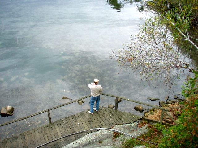
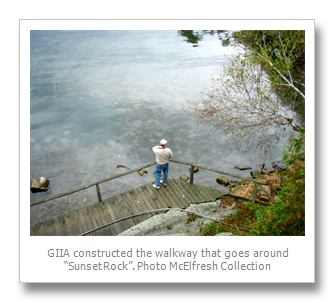
Besides, cutting the grass, the GIIA installed handrails over the more treacherous areas and constructed a wooden walkway to skirt “sunset rock,” currently owned by the Wallachs. The GIIA sought reimbursement from the Town of Clayton Road and Highway Department for maintenance of the sidewalks and paths and were successful, receiving around $50 a year in the early decades and up to $350 in later years. This came to a screeching halt in the early-1980s when the Town of Clayton gave the sidewalks back to the landowners.
I’ve been asked many questions about Clayton giving the sidewalks (and paths) back to landowners. “Does that mean my property line goes to the middle of the sidewalk?” is the most frequently asked. Unfortunately, I don’t have any answers. I’m not even 100% sure when it happened only to say 1983 was the last year that GIIA received funds from the Town of Clayton and 1984 was the first year the GIIA did not pay for grass cutting of the path. Other than that telltale fact, I can find no reference to it in the minutes.
The transition was seemingly smooth. Even before the 1980s, the residents on the north side were already maintaining the “public path” where it crossed their property. I chuckled when I read this in the 1973 minutes:
“Mrs. Kimber reported that the north island paths were unsatisfactory and in need of “toe-stubber rocks” removal. She has had two accidents as a result of the path’s condition. Mr. Kimber questioned if path clearing was the responsibility of property owners. Without legal advice, this question could not be answered at this meeting.”
Long time residents remember fondly that the sidewalk near Miss Preston’s cottage (today’s Bees Nest Cottage owned by Sollie’s) was lined with white rocks. Miss Preston was nearly blind and she needed the white rocks to help guide her when she walked from her cottage to the nearby store.
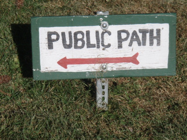
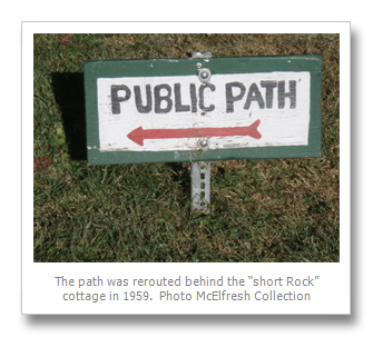
There were some grumblings in 1959 about the relocation of the path. (Like most communities, Grenellians are notorious for resisting change.) The Stoddards on the NW corner of Grenell (Short Rock) had relocated their cottage and at the same time high water had washed away some of the shoreline. So they relocated the public path from the front of their then new cottage to behind their cottage. Signs were made and still mark the “new” location of the path over 50 years later.
The only time there was a problem with the “public path” was on the east side of the island. Apparently, the 1880-era Grenell Island Lot Map was drawn after the first several lots had already been sold on the east shore. There is no public easement on these maps and no highway across these lots.
The lack of a formal easement on the east side hadn’t been an issue, at least for the first 56 years. That all changed in 1936 when the owner of Lot #61, a Frank Babcock, refused to let anyone cross his property and had filed an injunction in court to prevent access. I remember hearing murmurings that he even built a fence to keep people from crossing his property, but I’m not sure if this is true.
J. D. Babcock, a billiard table manufacturer from Syracuse, was the original owner of Lot #61. His cottage stood on the lot between the where the Walsh’s cottage is now and the Community House. He also built two other cottages on nearby lots that he used as rentals. His cottage burned to the ground in 1912. I found a reference to him in a 1914 social column saying he was vacationing on Grenell Island, perhaps staying in one of his rentals, but no mention of him after that. There is no one by the name of Babcock listed on GIIA membership lists. He was never a member of the GIIA.
I can only assume that Frank Babcock was a relative of the original owner, J.D. Babcock. Legally, Babcock had every right to refuse to let people walk across his property, but his actions made it difficult for cottagers on the north side to access the Community House or attend chapel. As the Community House had opened two years prior to this and Babcock’s lot was next door, I would assume that traffic across his property had increased. Gary’s Great-Aunt Alice Pratt purchased the interior lots behind the cottages on the east shore from the North Boulevard to St. James Avenue. She leased a four-foot right of way to the GIIA for a $1 a year to complete the circuit around the island. The GIIA formed a committee and went to work. Olivia Pratt describes the construction of the new path in The Story of Grenell this way:
“In the summer of 1936 there were many complaints that there were not suitable paths by which cottagers could walk all the way around the island…Volunteers for one day of free labor were asked for and twenty-one men and boys responded to the call. The women did their part by supplying cooling drinks to the workers. …That is the reason that the footpath goes over the camels hump, with steps of wood and concrete work, instead of along the shore, as on the north side.”
Doris Rasmussen remembers the path up through the woods in her early years on the island. She first arrived on the island in 1949. Gary McElfresh, whose first year on the island was the summer of 1952 as an infant, only remembers the path as it is now. So sometime between 1949 and the mid-1950s the trail up over the Camel’s Hump was abandoned.
In 2008, Charlene Richards helped me rebuild the path over the Camel’s Hump, though not in the same location. The original path ran too close to the backs of the cottages on the eastern shore and wanting to give my neighbors more privacy and the hikers better views, we located our path further up the hill. Within two years, Mother Nature took back what we had cleared. And I can see that without diligent maintenance, paths quickly become overgrown and impassable.
Residents who grew up on the island in the 1960s say the non-sidewalk portion of Park Avenue from Nastasi’s Pump House to where it meets North Boulevard was wide and grassless because of the pitter patter of young feet tramping to and from the store. The store was a popular destination in those days. Whenever kids found a nickel or two lying around, they made a beeline to the store to buy candy or a soda. Fireballs were popular. I heard many stories about getting a fireball from the store and by the time the youngsters reached Nastasi’s place next to the water pump, the heat of the fireball would rocket them down the hill and straight into the water. I’m told North Boulevard seems narrower today than it did in the 1960s. Park Avenue has changed too. Now where it runs between Johansons and Wards, there is a lush green lawn.
Many on the island have the habit of taking daily walks. Some prefer mornings. Others, like Tim Dennehy, take a walk around the island after dinner. Sometimes you’ll see families out for a stroll, the younger ones in life jackets. And then there are the dedicated health enthusiasts who run around the island. One lap around the island is a little less than a mile.
In his second book, Water, Wind and Sky, Ian Coristine has a picture taken from his walk around Grenell. The caption reads: Grenell islanders share more than a lovely island. They worship in a beautiful century old chapel, share a community house that also serves as post office and library and delight in a perimeter path that passes through each property as it circles the island. A casual stroll becomes a major social event as I discovered on a tour of the island with my Grenell friends, the Leys.” I can’t say it any better than that.
By Lynn E. McElfresh, Grenell Island
Lynn McElfresh is a regular contributor to TI Life. This year Lynn is helping capture the history of her Grenell Island. Last month Lynn wrote two articles, in Borrowing Books…she explains what borrowing books is like on Grenell and the Post Office on Grenell. We have learned a great deal over the past two years from her musings, from moving pianos to island weddings or from plumbing problems to meeting old friends, taking nature walks and the importance of trees. To see all of Lynn’s island experiences search TI Life under Lynn E. McElfresh.
The photos presented in this article and slide show are attributed to the McElfresh Family Collection.