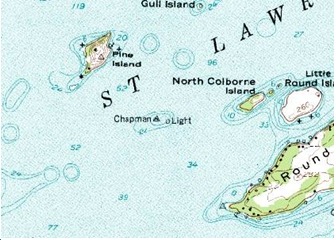
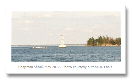
Chapman Shoal is located between Round Island and Pine (AKA: Beckwith) Island in the St. Lawrence River downriver from Clayton, New York.
The mystery is just this; for whom was the shoal named? On 1 January 2000 the USBGN recognized Chapman’s Shoal as a “non-controversial” “Variant Name.”
|
|
Chapman Shoal
The latitude and longitude (GPS) is N 44.2575 and W -76.07167.
Officially according to the Geographic Names Information System (GNIS) Chapman Shoal is a “Bar.” The definition of a Bar according to GNIS is “Natural accumulation of sand, gravel, or alluvium forming an underwater or exposed embankment (ledge, reef, sandbar, shoal, spit).”
|
Possibilities
My first thought was Charles Frederick Chapman, a familiar name to anyone who has piloted a boat. He was the original author of Chapman Piloting & Seamanship, first published in 1922. It is a must have book for any boater and is currently in its 66th edition; although Chapman died at the age of 95 in 1976. He was born in 1881 making him just ten years old; when in 1891, according to the United States Board of Geographic Names (USBGN) the shoal was officially named Chapman Shoal. Those facts eliminate C. F. Chapman.
I checked with Susan Smith, author of The First Summer People: Thousand Islands 1650-1910 (Stoddart, 1993), who researched over 250 island names given by Captain William FitzWilliam Owen on the first hydrographic survey of the St. Lawrence River in 1818. Susan assured me that the name Chapman was not recorded on the Owen Charts. Pearson Island (Now Round Island) Beckwith (Pine) and Colborne(North Colborne) Islands were recorded and the little shoal is well marked as a series of Xs in a small circle, signifying a serious navigation hazard. Also the name does not appear on an 1897 printed map from London, (Published at the Admiralty, 7th June 1897). Therefore we can assume the name Chapman is modern.
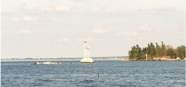
The Lake Carrier’s Association announced in their 1924 publication that “steel towers were placed and electric flashing lights” on Chapman Shoal. Up and until that time the buoy marking the shoal frequently was washed down river by the river current, causing extreme danger to navigation. The Oswego Palladium on 19 October 1932, reported that the shoal would be “removed by dredging early in the spring.”
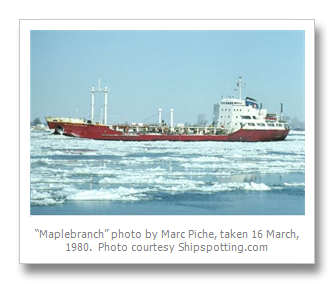
An accident occurred May 1959, as described by Utica Daily Press on Wednesday, 13 May 1959 a 375 foot Canadian oil tanker. The “Maplebranch” struck Chapman Shoal on Monday but managed to get to the Clayton Docks, where it sank with 51,000 barrels of crude oil. The oil was off loaded on to another tanker sent by the Branch Line of which the newly launched “Maplebranch” was the flagship.
W.D. Chapman?
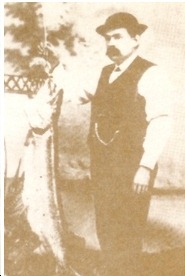
Another serious possibility for the shoal’s namesake could be William Dana Chapman born in Theresa, New York in 1820. His father was Dudley Chapman from Massachusetts; the family were early pioneers of Jefferson County. W. D. was an inventor with a number of patents to his credit including fishing tackle, a typewriter, a spring letter holder, and a rotary escape movement for watches.
W. D. loved fishing his whole life; as a child he played hooky one day and went fishing with a buddy in this Indian River. They caught a boat load of fish; but W. D. was afraid of repercussions from his father as it was Sunday and he had skipped church, but when his dad saw the bountiful catch all was forgiven.
W. D. was involved in a number of enterprises in Theresa, Brockville, and Rochester. The fishing tackle business was the one business that brought him international fame; to this day there are avid collectors of Chapman Lures.
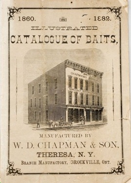
Reviewing the records at the USGNIS it is noted that the shoal was officially named “Chapman Shoal” in 1891, it would not be a stretch to imagine it being named for W. D. Chapman. At that time W. D. had reached the pinnacle of success in the fishing tackle business. His factory in Theresa was partially burned in 1890, but he was able to fill his backlog of orders and by 1891 he had repaired and added to the fire damaged building. In addition, W. D. was well connected in political and social circles; he was a close friend of Governor Roswell P. Flower
Captain Frank Chapman?
Capt. Frank Chapman was a prominent river resident at the time of the official naming. Chapman lived in Ogdensburg, New York. Frank and his wife, Harriet owned Halfway Island located downriver of Hemlock Island, halfway between Grenadier Island (Canada) and US mainland. Frank operated silk mills in Ogdensburg, which employed 400 people in 1910. He was also president of the Ogdensburg Bank, organized in 1879. He was also owner of at least one steamboat; the John Rugee purchased in 1899. He was born in Morristown in 1850, where his father, Richard B. Chapman, operated a grain elevator. Frank was descended from Augustus Chapman an early settler of Morristown and a substantial land owner. Frank moved to Ogdensburg and was extremely prominent in the business community; he died in 1919.
Those facts seem to indicate that Frank could have been the shoal’s namesake. No concrete evidence has been found so far to substantiate the assumption.
A thorough review at the Jefferson County Clerk’s Office shows no Chapman ever owned the shoal. In fact the ownership went from the original patent of islands to Elisha Camp in 1823 to the present owners, the Balcom Family of Clayton. They purchased it at a Jefferson County Tax Sale on 12 September 1983 for $31.50!.
Thus the mystery goes unsolved, perhaps one of TI LIfe’s readers has an idea, please send us your comments.
By Rexford M. Ennis, Grindstone Island
© Copyright Rexford M. Ennis 2012, All Rights Reserved
Rex Ennis has written several articles for TI Life. His bio is recorded in Contributors in December, 2008. In the past two years Rex has published two important books on the Thousand Islands. The first , published in 2010 is Toujours Jeune Always Young the biography of Charles G. Emery. It was reviewed in June 2010 issue. The second, Saints, Sinners and Sailors of the Gilded Age: A compendium of biographical sketches centered on the Gilded Age in the Thousand Islands which describes the biographies of every name appearing on a 1889 map published by Frank H. Taylor called: Map of the Thousand Islands; Hotels, Parks and Cottages. See the book review in our July 2011 issue and you will find the map described in the July issue in the August 2011 issue.
Do you have a question about your island name? Send them in, and we will try to provide answers.