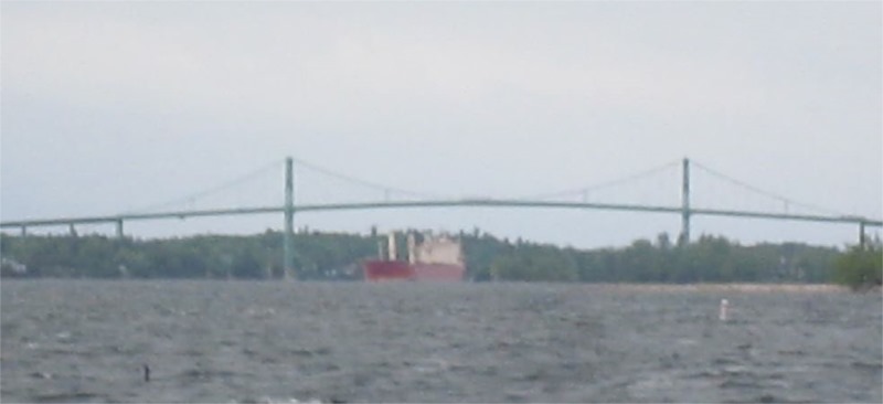
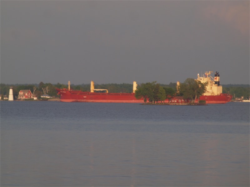
We were crossing the channel Wednesday morning, May 28th when my husband, Gary, shouted out, “Ship!” I had been looking upriver toward Clayton, but turned to look down river. There, in the gray, misty morning, I saw a red-hulled ship with a light yellow super structure, coming up river just this side of the Thousand Islands Bridge. Seconds later, Gary said, “That ship looks like it’s at an odd angle.”
He was right. We were in the middle of the channel. The ship should’ve been heading straight for us. Instead, it looked like it was headed towards Fishers Landing. We passed a green channel marker and lining up the markers, I could see the ship was definitely not in the channel.
At that moment, I thought we were seeing events in real time—that I was seeing a disaster in progress. My Paul Revere instincts kicked-in and I felt the need to send out an alert, to warn people.
We kept our eye on the ship as we passed Rock Island Lighthouse. As we passed Pine Island, Gary said, “I don’t think that ship is moving.” I noticed that it was listing slightly to port. No need to warn the villagers, I concluded—the ship had already come to a stop.
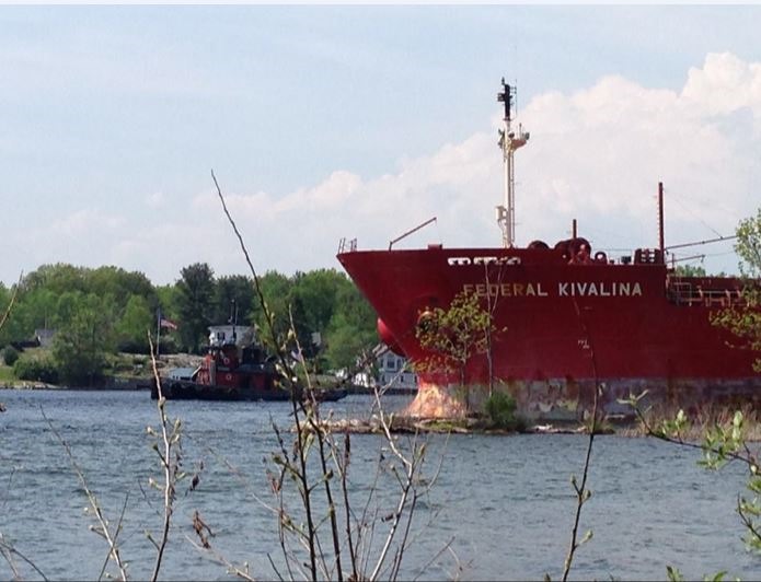
We didn’t find out until after we docked at Fishers Landing, that we were 19 hours out of the loop. The Federal Kivalina ran aground at 2:00 pm the day before, (May 27th) just upriver of the Thousand Islands Bridge. Linda, who works at Chalks Marina, told us she was pumping gas at the dock, when she saw the freighter coming down river. It was in the middle of the channel, the sun was shining on it and she had commented that it was so pretty, she wished she had a camera to take a picture of it.
“It was going down river?” I asked. Then I remember I’d seen a similarly colored ship, going down river yesterday afternoon. But the down-bound freighter was definitely facing upriver now. Reportedly, having lost steering and wanting to avoid possible impact with the Thousand Islands Bridge, the Federal Kivalina dropped three anchors as it swung 180° and ended up facing upriver. Linda said that she had heard someone had videoed the incident.
This is the first freighter I’ve ever seen aground, though I never was able to get very close to it. Officials kept looky-lou’s away, both by land and by water. We could see the super structure sticking-up through the trees near the New York shoreline, as we drove down Route 12; by the time we turned on Seaway Avenue past the 1000 Island Winery and headed to the water, Private Drive and No Trespassing signs had been posted.
The only other Seaway vessel I’ve seen grounded, was a barge. On July 27th, 2004 a Canadian tug named Salvor, pushing a single-hull tank barge, lost steering and ran into an island just upriver from Boldt Castle. I remember floating downriver and gasping when I saw how close it was to hitting Alster Tower or the Children’s Playhouse, which sits on the water’s edge at Heart Island.
In 2005, the Canadian Steamship Line freighter Niagara, lost steering and ran aground on the other side of the bridge, near St. Helena Island. It was there less than 24 hours. Crew repaired the small hole in the hull and she was in transit the next morning. I was attending a funeral in Illinois at the time and missed seeing that freighter aground.
My view of the Seaway, from the NE point on Grenell Island, is only 3 and half minutes long. I can see ships as they pass between the tip of Do-Syl-Mar Island (locally referred to as Pullman Island) and the tip of Thousand Island Park. As I’ve watched ships glide up and down the river, passing Castle Francis and Twin Island I think how wonderful it would be to have such an up-close and personal view of passing ships. But at the same time, the close proximity of these islands to the Seaway looks very precarious. How easily it seems that a huge freighter could decimate a small island. But structural damage aside, bricks and mortar are a lot easier to replace then possible impact on the environment.
Take for example the Spill of ‘76; on June 23rd, 1976, a tugboat pushing a barge ran aground in the American Narrows spilling 300,000 US gallons of crude oil, into the St. Lawrence, causing one of the largest inland oil spills, not just in the St. Lawrence---but in all of North America. We were not on the river at the time, but living in Illinois. My in-laws phoned to let us know that Chalks Marina had put a collar around the entire marina to protect the boats, even though the spill was downriver. Life down river was covered with the oil as far as Massena and Brockville.
For 122 days, muck boats gathered oily debris. The clean up effort stopped in October, though the 700 workers were not able to clean everything, in that amount of time. Many areas contaminated by the oil were just left for the oil, to degrade naturally.
People and property were affected for 80 miles downriver. The impact on wildlife was even more devastating; birds, ducks and other waterfowl were killed by the hundreds. Countless fish were harmed or killed by the spill.
The spill prompted the forming of Save the River, in 1978, and other Riverkeeper groups along the St. Lawrence. Thursday afternoon, we received this update from Lee Willbanks, executive director of Save the River:
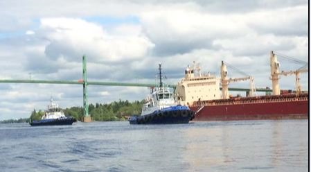
“The Current Situation: Ship traffic is stopped until the vessel can be refloated and salvaged. Currently seventeen ships are on anchor. waiting for this narrow portion of the River to be cleared. The ship is carrying canola meal, but also has approximately 100,000 gallons of fuel on board. No spill has been reported and the Coast Guard has deployed boom downriver as a precaution.
Divers completed an inspection of the vessel Wednesday, and found a two foot long hole in the hull near the bow. This confirms reports that she is taking on water. It is reportedly being managed with onboard pumps. Of concern is the possibility that ballast water on board will need to be released in order to re-float the vessel. However, the ballast water was reportedly tested by Transport Canada before the ship entered the Seaway and it complied with regulations.”
Our Concerns as Riverkeeper: We have had three incidents in the two months since the Seaway opened, with the most recent one occurring under the best possible conditions for navigation—no ice, buoys in place, high water, calm seas, full daylight. We need answers and we need safeguards. Too much is at stake for the environment and our communities who rely on a healthy River.”
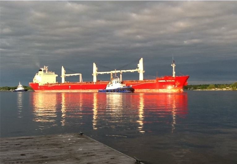
Talking later with Stephanie Weiss, assistant director, at Save the River, I learned that Collins Landing, where Federal Kivalina came to rest, is the location of a muskie spawning ground and adjacent to a tern colony. While we can breathe a sigh of relief, that there was no oil spill and no repeat of the devastation of the 1976 disaster, time will only tell if there was any damage to the Muskie spawning grounds or tern colony.
The barge that ran aground in 2004, didn’t damage any historically significant buildings, but it did spill 12,000 gallons of liquid calcium chloride, into the St. Lawrence, right across from Alexandria Bay. Luckily, that’s just salt. The CSL Niagara was carrying a load of coke, in 2005 and fortunately didn’t have a fuel spill.
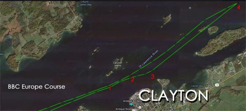
When I looked on YouTube, hoping to find the video of the Federal Kilavina which Linda had told me about, I found instead a video of the Federal Kivalina, where it had run aground in Norway, in 2008, again with no loss of life or serious impact on the environment. Upon further investigation I learned that a freighter, BBC Europe, did a 180˚ in the St. Lawrence Seaway, near Round Island on May 24th. Satellite tracking indicates that the freighter may have at least brushed a shoal, but as the ship did not stay in the area, it’s hard to tell. Go to http://www.theshipwatcher.com to see the details. Two Seaway incidents, only days apart? Both, in our section of the River?
How many close calls are we allowed?
By Lynn McElfresh, Grenell Island
Lynn is a regular contributor to TI Life, writing stories dealing with her favorite Grenell Island and island life. Back in June 2011 Lynn introduced us to the game of SHIP. Be sure to have a look at that one too. How many of us play that game?
You can see Lynn’s 69 articles here – as she helps us move pianos, fix the plumbing and walk with nature… As Editor, I have the pleasure of seeing “what’s next,” first!