Written by
Lynn E. McElfresh posted on December 13, 2014 12:36
I grew up landlocked. The only natural body of water in my hometown was called the Bone Yard Creek, which in reality was a glorified drainage ditch. As I started doing research on island history, I came across terminology I was unfamiliar with.
I use these terms all the time now. Some of you might know what I’m talking about, but there might be those of you who are as confused as I used to be, so here’s a little tutorial on island terms. Yes, there will be a test later. So pay attention!
WHICH WAY IS UP?
First you need to understand the terms, upriver and downriver. “Up” refers to the source of the river. The St. Lawrence River flows out of Lake Ontario, so upriver is toward the lake. “Down” refers to the where the river flows. The St. Lawrence River empties into the Gulf of St. Lawrence and the Atlantic Ocean. Personally, it felt odd to me to say “downriver” when I know the river is running NE; and on the map it looks like it is flowing “up.
HEAD TO TOE
Each island has a head and a foot. The head of the island is the upriver side of the island, while the foot is the downriver side of the island. Our cottage is located at the foot of Grenell, meaning we are on the downriver side of Grenell.
FRONT TO BACK
I often heard the north side of Grenell referred to as the backside of the island, but was never quite sure why. Came to find out that the front side of an island is the side that faces the main channel, making the other side, the backside; even if there is another island between the channel and the island in question. The side that faces the main channel is called the “front” side.
Once I understood these terms it made reading old newspaper articles much easier. If I read, Roger Lewis built a cottage on the foot of Grenell in 1895. I knew where to start looking. Likewise the statement: The Smiths built a new boathouse on the backside of Grenell, helped me narrow down which of the boathouses on Grenell the Smith boathouse might be.
NOW FOR THE TEST…
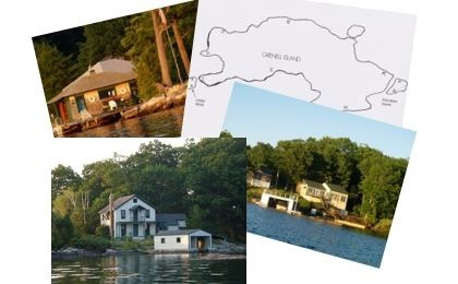
Here are cottages on Grenell, Pullman and near-by Long Rock. Can you match the description with the letter on the chart?
 |
Picture 1: Cottages on the front side of Grenell |
Picture 2: Cottages at the head of Grenell, on the backside of the island

|
Picture 3 Cottage at the head of the island, on the front side of the island.
 |
Picture 4 Dock and tower on the back side of Long Rock
 |
Picture 5 Not on the map, but view of the front of Long Rock.
 |
Picture 6 The skiff house at the foot of Long Rock, near the front side of the island.
 |
Picture 7 A cottage at the head of Grenell.
 |
Picture 8: Named Short Rock, this boathouse is near the head of Grenell Island, but on the backside of the island.
 |
Picture 9: The Cottages in Grenell’s Yacht Basin are on a half rock bluff on the front of the island near the foot of the island.
 |
Picture 10 The lovely California bungalow on Pullman Island is on the front of the island.
 |
Picture 11 This cottage is called Gazebo and is on the backside of the island.
 |
Answers?
The correct answers are attached to another story in this, December 2014, Issue.
Let us know how well you did by adding a comment to this article!
Happy Holidays from Lynn McElfresh and her Grenell Island neighbors. |
By Lynn E. McElfresh
Lynn McElfresh is a regular contributor to TI Life, writing stories dealing with her favorite Grenell Island and island life. You can see Lynn’s 70+ articles here – as she helps us move pianos, fix the plumbing and walk with nature.
During summer 2014, Lynn researched a number of new topics that she is sharing throughout the winter… As Editor, I have the pleasure of seeing “what’s next,” first! I certainly join her many friends and fans in thanking her for her wonderful stories.
Editor’s Note: This one gave me food for thought, and reminded me of a day getting gas at a marina many years ago. There was a fisherman asking directions and the gas-boy gave an easy explanation – “head south, then after you pass the island with the tennis court, head upriver, don’t stop until you see 40 Acres.” I knew right away the man was heading to Mermaid or Aubrey Islands, and it would be a simple voyage. But all was not so, as the fisherman pulled out his road map and asked if he could find the route on the map.”