|
Young kid: “Mister Zimmer do you know where all the shoals are in the River?”
Karl Zimmer: “Nope, but I know where they ain’t!”
|
In my early and later teen years I was fortunate to have my own boat during the summer, while living at my Grandmother’s cottage on Ontario Ave. at Thousand Island Park. The first was a 12’ foot open dinghy, salvaged from a rock pile in Short Hills, NJ and brought back to life by my father. Power you ask? A mighty five horse Johnson clamped on the stern. Two years later a major upgrade. A brand new 14’ Wagemaker Wolverine with a ten horse Johnson. If you are going to run a boat on the St. Lawrence you need to know where the shoals are and “where they ain’t.” I was the kid asking that question. Karl Zimmer was, for several years, the Dock Master at Thousand Island Park’s Main Dock.
Geologists tell us that the Great Lakes and the St. Lawrence River were created eons ago, by a combination of deep underground plate movements and glacial activity. The eastern most lakes, Erie and Ontario, along with the St. Lawrence River, are thought to be mostly formed by glacial movement. Imagine a wall of ice and snow, hundreds of feet high, grinding its way down to half past New Jersey, then slowly retreating north, melting along the way. That glacier carved out the 1000 Islands, some large and some very small. It also left shoals. They are nowhere and everywhere, none exactly the same, and all can be dangerous.
|

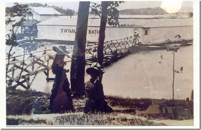
How Bath House Shoal got is name. In the late 1800's the walkway ran from the foot of Ontario Ave. on 1000 Island Park to the large structure built on and around the shoal. Photo by Melissa Parkhurst. Courtesy of Tom French 1000 Island Park Museum.
|
Out on the main shipping channel, Lake Boats and Salties know where shoals are. Today’s navigation helpers include radar and GPS, along with other 21st Century technology. A safe channel has been carefully plotted marked by red and green buoys. Through the overnight hours most of the main channel buoys feature flashing red or green lights for better visibility. So, while it can happen and has, these huge vessels seldom meet up with shoals in an unforeseen manner. Outside of those channels however, most of the rocks in the River are just little “X” marks on the navigation charts. To the boater unfamiliar with the waters of The St. Lawrence River, they are unseen trouble just waiting to happen. In recent years significant efforts have been made to mark these underwater hazards but that was not always the case. In my now long gone teen years, you ether knew where they were or you came to grief, hopefully with nothing more than a busted sheer pin to show for the experience.
Some shoals are named. Recognized titles include: Frontenac, Broadway, Pullman, Granite State, Chapman, Steeple and Niagara. In Canadian waters one has, apparently, been knighted; Sir William Shoal can be found west of the Canadian Span. (Its proximity to Sir William Island is the more logical reason for the name.) One tells it like it really is: Sunken Rock Shoal, and one decidedly like it is not: Featherbed Shoal.
Shoals can be deadly. Lives have been lost including Dana Feron in the summer of 2013. I never knew Dana but her father, Cal, was a part of our River Rat gang way back when.

“Fire”
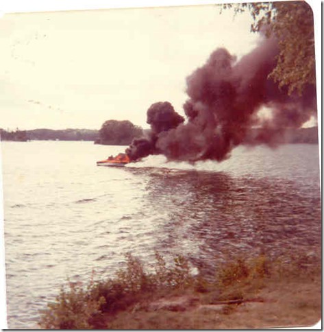
A very bad day on The River. While shoals can be dangerous Bath House served as a refuge for this unfortunate boatman. Photo by Richard Parkhurst
|
Shoals have been used for good purpose. As an example, Bathhouse Shoal, just off Thousand Island Park, between Wellesley and Grinnell Islands. This particular hunk of rock is aptly named. At one time, many years ago, there was a bathhouse built there with a walkway out from the Park. Bathers had a place to change into swim attire, before venturing into the chilly waters of the St. Lawrence. You could even rent a St. Lawrence skiff, for an oar powered ride, if you so desired. Today the bathhouse is long gone, but the name remains.
A rite of passage for kids, me included, was the ability to swim all the way to Bathhouse and back. A favorite event of my three sons was to swim out to Bathhouse and have seaweed fights. They would gleefully throw the green gooey stuff at each other, for no other reason than they were young males. The swim back did all the cleansing needed. Last summer my grandsons made the swim. Deja vu over again.
Bathhouse is one of three in the immediate area. Wheaton is closest to Grinnell, while what we called Mid Shoal lies between. The middle one was usually far enough down to not cause problems, but still something of a shock to see all of sudden, while thinking you were in safe water. Wheaton occasionally would sport a small bush of some kind, making us wonder if by that stroke of nature it suddenly became an island. A long anticipated visit to the area last July showed a marker on that mid shoal. Good move.

“Boat vs Shoal”
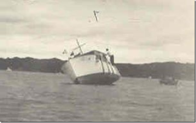
The year Bath House was invisible. High water just barely covered the shoal and by Labor Day 23 outboards, three inboards and this unfortunate small cruiser hit or ran aground. Photo D. Parkhurst Collection.
|
Like all the other shoals, Bathhouse could cause problems. Before the St. Lawrence Seaway was constructed River levels varied greatly. One year water would be over our swimming rocks, at the foot of Ontario Ave., the next year well below. The exact time line escapes me but one summer in the middle1950s, River water just barely covered Bathhouse. It was invisible to anyone traveling on the water, you had to know where it was and by that manner only. That unknown year took its toll on many unwary boatmen. By Labor Day the count was twenty three outboards, (mostly rentals from Chalks, at Fisher’s Landing) three inboards and one small cruiser. All had either grazed, hit or run aground on the shoal. Trying to help, T I Park resident and attorney George Stevens, painted an empty gallon gas can white, then anchored it off Bathhouse as a warning. It was removed by some New York State or Federal agency with the explanation that it was not an “approved” marker. Perfect proof that bureaucratic stupidity was alive and well back then, as it is today.
That cruiser grounding was a major event. Outboards seldom had little more than a broken sheer pin to show for the hit while the inboards usually sustained some damage to the bottom, rudder and/or prop. If grounded they could, and were, pulled off easily with the help of a passing fellow boater. Not so the cruiser. There were several attempts to pull the boat off of Bathhouse but to no avail. The cruiser was fully grounded, as the photo shows, and no amount of pulling from even a large inboard, would move it an inch. It took a while, but finally a commercial work boat from Alexandria Bay came up and pulled it off. We never found out what damage had been done, but it did cruise away under its own power.
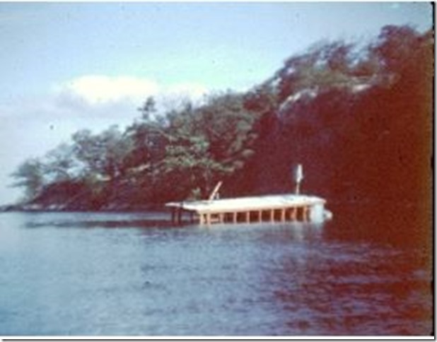
Another victim of Bathhouse, a few years later, was a small tour boat. I cannot remember who was operating the craft, but it had to be someone very unlucky or, more likely, unfamiliar with the water on that part of the River. It did not hit the shoal, but did graze the rocks. The boat made it to the mouth of the narrows, between Wellesley and Murray, before settling to the bottom. It remained there for several days before crews, again from Alex Bay, came up with heavy recovery equipment to raise the boat and carry it away on a barge brought along for the operation. Had the driver gone just a bit further recovery would have been far more difficult, as the water is quite deep just a few feet further into the Narrows, toward Eel Bay. It also would have made navigating through “The Gut” difficult and dangerous for anyone attempting to go through.
Many years later, another boat would have problems near Bathhouse. The shoal probably was not the cause of the fire, but did serve as a point of refuge for the unfortunate owner, giving him a place to escape the flames. Not sure of the details, as I was long gone from the area at the time. The photo was taken by my father, and his failing memory could not recall what exactly had happened, other than it had been beached on Bathhouse as the fire destroyed the boat. It too was taken to Alex Bay for repair or more likely scrap.

“Tour Boat”
After apparently grazing Bath House Shoal this small tour boat made it to the mouth of the narrows before settling to the bottom. Photo D. Parkhurst Collection.
|
Again years ago, there was a large marker, apparently approved, just off the Rochester Hotel* dock. Round and white, my Mother called it the “Bathing Cap” simply because that’s what it looked like, at least to her. Yes, girls did wear those rubber head coverings to keep their hair dry in those days. I doubt you would see one today on anyone under the age of 90. The marker was removed at some point, by whom and why I have no idea. We never felt there was a danger, as the shoal lies quite deep in the water. It must still be considered a possible threat, as a visit this past summer showed a marker where the “Bathing Cap” once stood guard.
Shoals take on varying shapes and sizes. A large field of small rocks lies just off Castle Francis Island, toward the Main Channel. Again, unless the water was unusually low, not a hazard but still there. A hunk of rock sits majestically between Grinnell and Murray Islands while just under the water danger lurks off Grinnell towards Hub.
Black Rock Shoal off Goat Island, is somewhat unique as you can run as close as you wish on the island side, but woe to anyone attempting to pass on the other. A long slope of rock tapers off for ten to fifteen feet, before safe water is available.
Sailboat races were run every Sunday afternoon at the Main Dock by the, then, loosely named T I Park Yacht Club. The prescribed course included Black Rock, since usually, depending on wind direction, this was the final turn before the home stretch to the finish line. Baldwinsville Newspaper Publisher Don Brown, had the shoal timed perfectly. His Lightning sailboat was a frequent winner in its class, made possible by his discovery, and daring, that he could skim so close to Black Rock you could almost reach out and touch it. He would pull the centerboard up several inches, for a few seconds during the maneuver, just as a precaution. I had the experience of crewing for him on several occasions and that part was especially exciting. The maneuvre shaved precious seconds from his overall time.
One of the nicest compliments I ever received was from an old girlfriend. Married with three kids, we had come back east to visit my parents at T I Park. By pure chance we happened to meet the young lady, now married with two daughters of her own, and were invited out on the water on her inboard. She offered me the wheel, which was a genuine pleasure, but her daughters were not so sure. “Does he know where the shoals are” one asked her mother? “He taught me!” was the reply. Felt about ten feet tall for a week.
Our visit this past summer gave me the opportunity to remember those shoal locations. A rental from Clayton gave us the chance to spend some real time on the deep blue waters of the St. Lawrence. What a change from years ago. My son Brian downloaded a chart onto his smart phone, just in case. Didn’t need it.
That glacier is long gone of course, leaving behind the beauty of the 1000 Islands along with the rocks in the River we know as shoals.
|
* The Rochester Hotel
Situated on Coast Ave., between Star and Union Avenues, the Rochester Hotel consisted of five buildings. Four were actually large cottages that had been converted into individual hotel rooms and/or suites, while the fifth had been built specifically for the hotel. It contained the hotel dining room, kitchen and dormitory for the summer staff. Girls were housed on the second floor, boys on the third. That utility building has since been torn down and the cottages reverted to private ownership.
|
By Deane C. Parkhurst
Deane C. Parkhurst was born on June 8th 1934 in New Jersey. He writes; “So-so grades in school, endured ten months of the year in NJ, happy at TIP for two. In college ‘majored’ in the college radio station instead of class. Drafted into the Army in 1957 and served two years in the Signal Corps.” He worked in commercial radio and television in New York State until moving to Mid America. He completed his career selling high end computer systems to media companies; retiring in 2005. Back in August 13, 2013, Deane wrote Remembering TI Park and the Hurricane of ‘38 for “TI Life” and in September 2014 he wrote, “You Can’t Go Home Again!” (Or Can You?). Today Deane lives in Olathe, KS, on the border of Kansas City, MO. He writes, “ Living in the Kansas City area has been great, it's just so hard to find ocean front property.”