Dr. Douglas J. Pippin, Star Carter, and I are standing on the embankment at Fort Haldimand, a British Fort built on Carleton island.
Today the fort is owned by the Thousand Islands Land Trust (TILT). It is located at the head of the Carleton lsland in the United States. I know a “bit” about the Fort but my knowledge is scant and Doug, as they say, “wrote the book!”
Doug grew up near Rochester at Victor near the site of Ganondagan, a Seneca village burned to the ground by the Marquis de Denonville in July, 1687. Living near an historic site definitely made an impression on him and by the age of 11 he decided that the science of anthropology was fascinating!
He received his first degree, a B.S. in Journalism from the University of Maryland, at College Park in 1990. During his senior year he was chosen for an internship at the Smithsonian Institution in Washington, This led to enrollment in a Masters in Anthropology program, at Syracuse ,in 1996. It was during his Syracuse days that he began his partnership with the Thousand Islands Land Trust.
In 1996 TILT hired a young man, Aaron Vogel, as a summer intern (He later became Director of Land Stewardship and then served as Executive Director of TILT until his untimely death at age 39 in 2008). Aaron, then completing his degree at SUNY College of Environmental Science and Forestry took a course in Archaeology at Syracuse University with Doug and he knew that Doug’s findings, at another site, were scant.
Doug remembers Aaron’s call: “Doug, I am working for the Land Trust and one of their properties is the site of an old British Fort, Fort Haldimand. How about coming out to see it?” Doug soon became a regular visitor to Carleton Island and began what could easily be a “lifetime of study”.
His thesis entitled: For want of provisions: An archaeological and historical investigation of the British soldier at Fort Haldimand (1778--1784) was published in 2010 when he received his PhD in Anthropology from Syracuse University. Today he is teaching Anthropology and Archaeology at State University of New York, Oswego.
During the trip I asked Doug what made Fort Haldimand so unique. He was quick to state, “Neither before, or after, the American Revolution was Fort Haldimand ever occupied by the French or American armies. This makes it a distinctly British outpost and an important location for archaeological study. All of the research at Fort Haldimand has been conducted through the generous donation of time, equipment and, most importantly of course, boats so that we could get to our site. From the clean up and preservation of the extant earthworks, to the excavations that formed the basis of my dissertation research, we have had outstanding public contributions.”
He also explained “Efforts to arrest the further deterioration of the fort and its extant remains are an important part of the research at Fort Haldimand. The interior limit of the fort has become approximately 60% covered in sumac and lilac. There are almost no substantial trees within or near the fort, as the shallow soil depth doesn’t allow for deep root systems. The sumac trees pervasive in the fort, seen in on photographs, thrives in this environment and rarely penetrates more than 10-15 centimeters below the surface. The extent of the vegetation within the fort was recorded and mapped in 2002 using GPS equipment. The increased vegetation within the fort affects both the extant features and the sub-surface deposits. This study, too, and the use of the equipment, was conducted on a volunteer basis.”
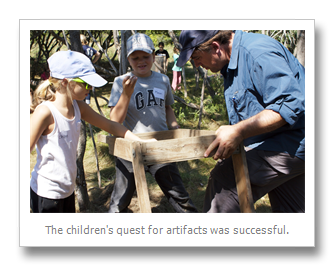
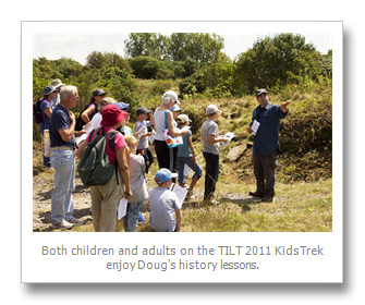
This summer Doug and his graduate students are back on the island and TILT organized three special days for visitors. The first trip included over 20 volunteers who worked two days bringing equipment and clearing the Fort of Sumac trees and overgrowth. The next trip brought a lucky 15 to join Doug and have a guided history tour. The final excursion brought 20 young people, on what TILT calls a KidsTrek. All visitors – volunteers, adults and children - agreed that it was an experience few will forget.
Throughout his years of study, and especially for his thesis, he often makes an effort to thank many who have brought an interest on this old fort including his dissertation committee chaired by Christopher DeCorse as well as all the volunteers too numerous to mention that stepped up to help with the excavations at Fort Haldimand. Among these were William M. Beauchamp and Thousand Islands Chapters of the New York Archaeological Association, the Thousand Islands Land Trust and the Antique Boat Museum in Clayton, NY, and of course, the undergraduates from SUNY Oswego and Syracuse University. He also thanked the many interested residents of Northern New York State and the Province of Ontario.
TI Life asked if he would begin telling the unique story of discovering the Fort and the life of the British soldier on Carleton Island. We are pleased to present
Carleton Island, with photographs and descriptions by Dr. Douglas J. Pippin

Google image. 2008.
|
|
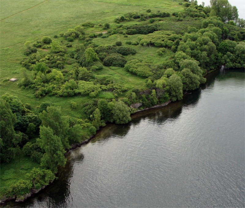
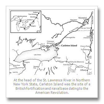
“At the head of the St. Lawrence River in Northern New York State, Carleton Island was the site of a British fortification and naval base dating to the American Revolution. For most of the nineteenth and twentieth centuries, restricted public access to the island was the greatest asset to the site’s preservation. But for more than 20 years, the Thousand Islands Land Trust has owned and protected the extant earthworks, dry-moat, artillery bastions, and features that make the fort easily discernable today. Archaeological investigations at the fortification––Fort Haldimand––benefited from active volunteer participation, and community interest in the site. This greater community awareness of the fort and the adjacent, underwater cultural resources had led to many new opportunities for both site preservation and research.”
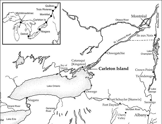
“In the late eighteenth century, the British outpost on Carleton Island was an important connection between the cities of Montréal and Québec, and frontier posts in the Great Lakes farther to the west. The diverse activity areas on Carleton Island included an earthen fortification, naval base, shipyard, and storage depot. Pubic archaeology at the fortification, Fort Haldimand, has revealed information about the soldiers’ access to provisions, living conditions in the barracks and availability of market goods. Among the principle inhabitants of the cabin were soldiers of the First Battalion, 84th Regiment of Foot, or Royal Highland Emigrants.”
|

Detail from Plan of Carleton Island, 1810 by A. Gray, Assistant Quartermaster General, North America (Library and Archives Canada, Map Collection. Used with permission).
|
|
“Positioned atop a sixty-foot bluff at the west end of Carleton Island, Fort Haldimand commanded a view of the head of the St. Lawrence River and Lake Ontario. A small peninsula in the shape of a hammerhead forms two bays below the bluff, known today simply as north and south bay, but previously known as Schank’s Harbour and Government Bay, respectively. On this peninsula was the area taken over for shipbuilding, naval stores and the sailors’ barracks. A road up to the fort from South Bay---cut out of the limestone by the British---emerges at the top of the bluff just to the south of the fort.”
“As part of an active supply line, Carleton Island was also home to several merchants’ representatives and their warehouses, indicated on this 1810 map with the notation “Merchant’s Point and Merchant’s Cove.”
|

© Douglas J. Pippin, PhD
|
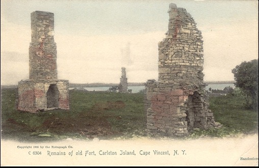
“The most striking element of the fort still visible today is the moat, approximately twenty feet wide, six feet deep and several hundred yards long. In the middle of each of the three sides, a bastion projects out from the wall. The purpose for the bastions was to provide placement for the fort’s artillery, facing inland to defend against an attack from across the island. The moat is only one element of the defensive works and extant remains, of which a great deal is still plainly visible, including two standing, and numerous other fallen chimneys.”
|
| |

Encampment of the Loyalists at Johnstown, 1784 by James Peachy (Library and Archives Canada, Map Collection. Used with permission)
|
|
“In addition to its military and economic roles, Carleton Island became a refuge for loyalists and Indians displaced by the American Revolutionary War. The loyalist settlement on the island would likely have resembled this contemporary image of a loyalist encampment down the St. Lawrence River in what is now Cornwall, Ontario. Although initially lacking support from the military, both Indians and loyalists would eventually draw rations from the garrison supply, placing further stress on the provisioning system.”
|

Stereo card image, “Bay of Carleton Island” by A. C. McIntyre. No date, approximately late 19th century.
|
|
“A.C. McIntyre made numerous trips to the island to produce stereoview photos of the landscape and ruins, and he documented the Thousand Islands extensively at the end of the 19th century. The popularity of these images led postcard photographers back to Carleton Island in the early 20th century.”
|
 |
|
“Dr. Hadley Kruczek-Aaron from SUNY Potsdam, who was at the time a graduate student, working with Syracuse University students in the discovery of the remains of an Imari porcelain cup. We found not only evidence of an intact wood floor, but also the rough-cut timber laid onto the bedrock as part of the barrack’s exterior cabin wall.”
|
 |
| “Here is Syracuse University graduate student Lori Lee, now an archaeologist at Poplar Forest (one of Thomas Jefferson’s plantations in Virginia), recording information at the main excavation trench. Students are recorded the debris from the cabin’s chimney. Another significant discovery was a substantial midden deposit along the side of the cabin facing the fort’s interior. This deposit has provided a wealth of information related to the soldiers who were garrisoned at Fort Haldimand.” |
 |
| “As you can see here, there is a very shallow soil depth to bedrock within the limits of Fort Haldimand. The barracks were laid down directly on the stone and the midden is only inches above the limestone bedrock.” |
|
“The 18th century military expansion in the St. Lawrence Valley was a direct result of the struggle for control over western settlement in North America, and access to the lucrative trade routes. British policy, however, left the frontier without an infrastructure to support their military during the war with the American Colonies. The influx of soldiers in Canada during the American Revolution stretched Great Britain’s ability to provide adequate food and supplies for their garrisons. Fort Haldimand was an important part of that supply network, and a excellent site for understanding the complex settlement of New York and Upper Canada.”
|
By Susan W. Smith, susansmith@thousandislandslife.com