Written by
Susan W. Smith posted on October 14, 2008 21:31
Throughout the winter, I will provide a number of links to demonstrate how our region of the mighty St. Lawrence River should be known as "The Thousand Islands, more than a salad dressing"! In September I provided a historic link to George Washington and the current presidential election. This month we make a link to the British Hydrographic Office in Taunton, England and Arthur Wellesley, the 1st Duke of Wellington.
Researching the history of island names has given me many hours of pleasure including a visit to the British Hydrographic Archives in Taunton, England. The following material may help our readers understand how I began my research, part of which is included in this issue of Thousand Islands Life under the heading: Historic Island Names.
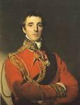
In the United States, we consider George Washington to be one of our most famous generals. In England, Arthur Wellesley, the 1st Duke of Wellington, would be high on the list. And, of course, it is Wellesley who is closely linked to our islands. In fact, we should think of him each time we cross the border from Canada to the United States at the Wellesley Island/Ivy Lea border crossing.
I will retell my favorite tale of my visit to Taunton, England.
I was in Taunton for only two days, and I was discouraged. I could not find some Canadian charts that I knew were in the British Hydrographic Department archives – I had seen photocopies, given to Canada by Britain, in the National Library and Archives of Canada.
Then just a couple of hours before I was to catch my train to London, I listened to a presentation given by the chief archivist to a group of British schoolchildren (not nearly as attentive as I was!). In describing the system of printing charts and explaining what an important service the British Hydrographic Department has performed for the Royal Navy and merchant fleets around the world, the archivist brought forth a leather-bound record book, crumbling with age. "This is the first record book," the archivist explained. "The first charts ever printed for the Navy are recorded in this book."
I nearly jumped across the table, for I knew the surveys in Canada were some of the earliest completed by the British Hydrographic office. As soon as the youngsters left the room, I gingerly opened the book (wearing gloves, of course). There on paper was the reference: Canadian Lakes, 1815-18 – our charts.
In minutes I was sitting at a chart table while the archivist unrolled Capt. William FitzWilliam Owen's hand-drawn map, dated 1816. It is beautifully illustrated and beautifully drawn. To the archivist's knowledge, it had not been unrolled for several decades, perhaps not for "over a century". At that moment I was able to see – firsthand – more than 250 islands identified by name.

The 1816 hand-drawn chart of the Thousand Islands used as the basis for the printed charts published in 1828 by the British Hydrographic Service.
Thus my quest for Thousand Islands history was generously enhanced. On that day I also learned more about Arthur Wellesley and, more importantly, the island that bears his name. First, Captain Owen named one of the largest islands in the Thousand Islands after Wellesley. At the time, 1816, Wellington was a war hero, having defeated Napoleon at the Battle of Waterloo. On the first charts, today's Lake of the Isles was called Lake Waterloo. In addition, each of the major points on the island was given names that commemorated battles that Wellington and his officers won for England. Before the hour was over I had recorded more than 255 island names – some of which were later engraved on the charts, while others disappeared and were never commemorated. If you have an interest, do continue researching the many battles that Wellington fought and learn, first-hand, how important they were to naming our islands.

Modern-day Wellesley Island taken by Ian Coristine. Today’s Lake of the Isles commemorated the Battle of Waterloo fought in 1815 and ended Napoleon's rule.
| Historic Name |
Present Name or Location |
| Wellesley Island |
Wellesley Island |
| Oporto Head |
Grand View Park |
| Toulouse Point |
Near the entrance to the International Rift |
| Badajoz Head |
International Rift (International Border) |
| Salamanca Point |
At the foot of Lake of the Isles |
| Bosaco Point |
North part of Thousand Island Park |
| Point Vittoria |
Mary's Island |
| Lake Waterloo |
Lake of the Isles |
Susan W. Smith SusanSmith@ThousandIslandsLife.com
More than a Salad Dressing… Years ago, I met a young medical student and I was telling her about my favorite vacation region. I got carried away, and soon I was relating facts about the War of 1812, the ships that plied the St. Lawrence River, the battles… “Gee,” she exclaimed, The Thousand Islands are more than a Salad Dressing”.
Over the past decade, I have presented a number of historical talks and the audience is always interested when I link events, people and happenings with the Thousand Islands. I refer to these links as six degrees of separation – and over the next few months, we will compile a long list to prove that the Thousand Islands is (almost) the center of the world – and certainly more than a salad dressing!
[Six degrees of separation refers to the idea that if you are one "step" away from each person you know, then you are two "steps" away from each person who is known by one of the people you know, and you are no more than six "steps" away from each person on earth. http://en.wikipedia.org/wiki/Six_degrees_of_separation.]